Tropical Disturbance, Invest 94W, to Pass Near or Through the Marianas
Monday, June 22, 2026, Valid at 12:00 PM ChST
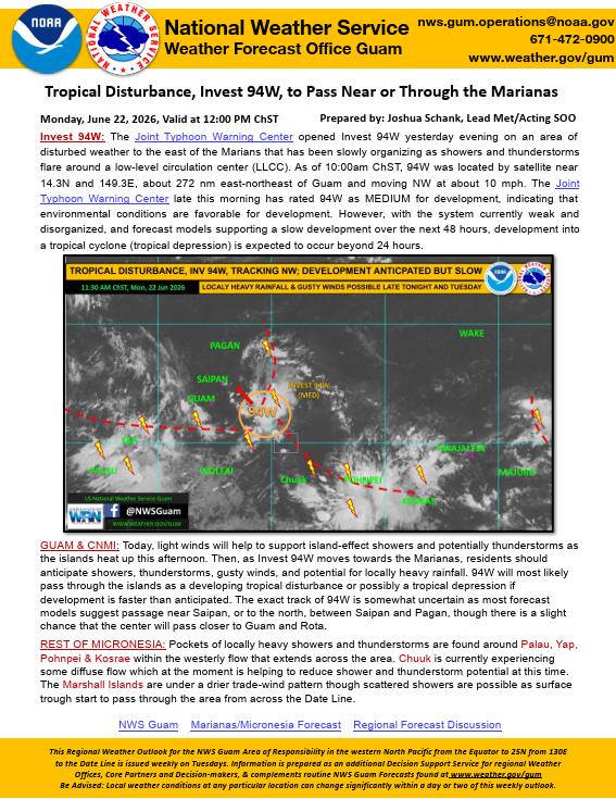
Invest 94W: The Joint Typhoon Warning Center opened Invest 94W yesterday evening on an area of disturbed weather to the east of the Marians that has been slowly organizing as showers and thunderstorms flare around a low-level circulation center (LLCC). As of 10:00am ChST, 94W was located by satellite near 14.3N and 149.3E, about 272 nm east-northeast of Guam and moving NW at about 10 mph. The Joint Typhoon Warning Center late this morning has rated 94W as MEDIUM for development, indicating that environmental conditions are favorable for development. However, with the system currently weak and disorganized, and forecast models supporting a slow development over the next 48 hours, development into a tropical cyclone (tropical depression) is expected to occur beyond 24 hours.
GUAM & CNMI: Today, light winds will help to support island-effect showers and potentially thunderstorms as the islands heat up this afternoon. Then, as Invest 94W moves towards the Marianas, residents should anticipate showers, thunderstorms, gusty winds, and potential for locally heavy rainfall. 94W will most likely pass through the islands as a developing tropical disturbance or possibly a tropical depression if development is faster than anticipated. The exact track of 94W is somewhat uncertain as most forecast models suggest passage near Saipan, or to the north, between Saipan and Pagan, though there is a slight chance that the center will pass closer to Guam and Rota.
REST OF MICRONESIA: Pockets of locally heavy showers and thunderstorms are found around Palau, Yap, Pohnpei & Kosrae within the westerly flow that extends across the area. Chuuk is currently experiencing some diffuse flow which at the moment is helping to reduce shower and thunderstorm potential at this time. The Marshall Islands are under a drier trade-wind pattern though scattered showers are possible as surface trough start to pass through the area from across the Date Line.
This Regional Weather Outlook for the NWS Guam Area of Responsibility in the western North Pacific from the Equator to 25N from 130E to the Date Line is issued weekly on Tuesdays. Information is prepared as an additional Decision Support Service for regional Weather Offices, Core Partners and Decision-makers, & complements routine NWS Guam Forecasts found at www.weather.gov/gum Be Advised: Local weather conditions at any particular location can change significantly within a day or two of this weekly outlook.
Share this article